From our local weather expert over at http://www.anguilla-weather.com/…
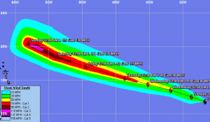
TS Katia (probably hurricane Katia by Wed.) is currently tracking to the NW about 2,100miles to our ESE. ALL forecast models call for Katia to pass well to our north on Sunday/Monday as a Cat 3 hurricane– currently about 300 miles north of AXA. Also, current reports show that the strongest winds will be to the north of the center – with 50 kt. + winds extending only about 50 miles to the south from the center. Sea swell forecast call for 10 – 12 ft. seas from the E and NE on Sunday – nothing extraordinary for AXA. I should point out that Crown Weather (http://www.crownweather.com ) stated in their report this morning that “…I am still leaning towards a track that takes Katia very close to, if not right over the northeastern Caribbean on Sunday and Monday..”, but not sure where they are coming from on this. No matter, with a possible Cat. 3 hurricane passing close to us, should keep a close eye on the track later in the week.

