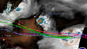
Just a heads up re: the now 4 Atlantic storms being tracked.
The one of concern to us is Storm 93L which is still over 2,100 miles to our east.
Current thought is the storm in front of 93L (slower moving Storm 92L) could be absorbed into 93L (but no matter – 92L is currently not a threat).
Although too far for any accurate forecast, models call for it to track over the northern islands sometime Tuesday/Wed. without reaching hurricane status. But it is a large storm and we should expect at least rain and some squalls mid-week.
Keep checking http://www.nhc.noaa.gov/index.shtml every 6 hours for updates.
More this weekend if conditions warrant. Here’s the latest satellite/model tracks:

From: http://www.anguilla-weather.com/

Leave a Reply